3d LiDAR annotations

3d LiDAR annotations

Exploring the Top 5 Challenges in Annotating 3D Point Cloud Data from LIDAR: Solutions and Best Practices

The LIDAR ( Light Detection and Ranging ) technology has become one of the foundations of a number of advanced technologies, including autonomous driving and robotics, smart cities and forestry management. The main importance of using LIDAR is its 3D point cloud data annotation, making it possible to teach the machine learning models to understand the real world in a three-dimensional format. Nevertheless, there are peculiar difficulties related to annotating 3D point clouds. In this case we would look at the 5 most common problems and suggest an effective solution or best practice that can help deal with them. 1. High Complexity and Volume of Data Challenge: The file size of 3D point clouds could be millions of points that reflect a complex environment with detail structure. Such dense datasets are hard to work with which makes annotators slow and prone to making errors. Solutions & Best Practices: 2. Poor Standardised Protocols of Annotation Challenge: In contrast to 2D image annotation, the 3D point cloud labelling has no common standards and leads to such issues as inconsistency and reduced dataset quality. Solutions & Best Practices: 3. Difficulty in Identifying Objects in Sparse or Occluded Areas Challenge: There are areas that lack point clouds or there are obstacles that hamper object identification and assigning labels to the objects unambiguously. Solutions & Best Practices: Multi-Sensor Fusion: Combine LIDAR data with camera images or radar to get complementary information. High-tech visualization: Work with tools where varying the point density of visualization and shift of viewpoint is possible. Contextual Labelling: Text annotations need to make use of context in a scene to deduce objects which are not visible. 4. Time-Consuming and Labor-Intensive Process Challenge: Labelling of 3D point clouds requires manual annotation that is more time-consuming compared to the 2D image annotation, which makes projects costlier and time-consuming. Solutions and best practices: Semi-Automatic Annotation: Use AI-based tools to tag the data in advance and then leave it to the annotators to fix the data in a short time. Active Learning: Model-in-the-loop based methods can be used in which the model proposes annotations to be verified by a human. Effective Design of the Workflow: Apply annotation workflows and reduce repetitive procedures and operations. 5. Handling Dynamic and Moving Objects Challenge: During high level uses such as autonomous driving, the objects change position between the frames of LIDAR, which makes it difficult to annotate the object related to a temporal sequence and tracking. Solutions and best practices: Conclusion It is important to annotate LIDAR-derived 3D point clouds data although it is a difficult task. With the introduction of standardized protocols, the use of advanced tools and AI support, multi-sensor data overlay, organizations will be able to raise the quality and efficiency of annotations by several orders of magnitude. All these are the best practices that can lead to the maximization of the possibility of the 3D LIDAR data into different innovative uses.

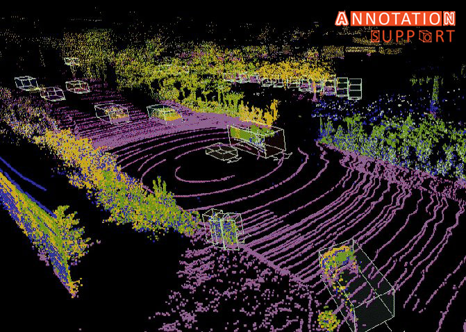
3d LiDAR annotations

Enhancing Accuracy and Efficiency: The Benefits of 3D Lidar Annotation Services

The 3D LiDAR dataset annotation services provide such advantages as an increase of precision and performance quality for a wide range of purposes, among them, autonomous driving, robotics, urban planning and virtual reality. Here’s how: Precision in Object Detection: LiDAR sensors give a close 3D point clouds having a high spatial information. This provides an accurate way for the definition of objects, like cars, walkers or cyclists. The performances of these objects detection algorithms are improved by it, therefore these systems become automated and reliable as well as safe. Detailed Scene Understanding: LiDAR annotation gives a better perception of environmental aspects of objects that include their semantics and geometry, for instance; how large they are, how they are shaped, and the direction in which their orientation is. This element provides algorithms with fine-tuned faculty to decode a complex scene and a factual basis to disregard irrelevancies and rationally respond. Being specific with this level of precision allows algorithms to deduce the intricacies of a scene and draw on contextual facts to make logical choices and disregard anything that is unnecessary. Improved Localization and Mapping: LiDAR annotation doubles-up SLAM algorithms in many ways, as it allows for detection of the environment landmarks and obstacles in high detail. This is a particularly salient benefit as it boosts the precision navigation of mobile platforms, even under complex circumstances or in a poorly structured environment. Efficient Data Annotation: By using AI to automate multiple stages of the data labelling process and combining staff specialist annotators, 3D LiDAR annotation services facilitate efficient annotation of massive point cloud datasets. Automated annotation eliminates the waste of manual annotation time and effort, resulting in the faster iteration and put into practice of AI. Scalability and Flexibility: The service of LiDAR annotation allows the consumer to deal with a high volume of data and covers flexible adaptation to various annotation requirements and situations. Annotation providers can do it by annotating LiDAR scans with objects for detection, semantic segmentation, or reconstruction of a scene. Shed them can do it according to the specific project needs. Quality Assurance: The annotation teams with professional LiDAR annotators adhere to multiple quality control guidelines to make sure annotations are precise and accurate and demonstrate consistency in the overall annotation sets. It reduces the trance of mistakes and makes the vocational data more reliable for the training and evaluation of the AI models as well. Domain Expertise: Human annotation of LiDAR services is successfully performed by annotators, who possess an in-depth understanding of domains like autonomous vehicles, robotics and geospatial analysis. This is one of the reasons why the AI experts resort to annotations in applications and the AI systems become relevant and significant for the real-world uses. 3D LiDAR annotation service can empower organizations to assimilate AI technologies to a better extent and speed up their building, at the same time that some advanced capabilities could be released. Those include the ability to be navigated and interacted with the 3D space. To know more about Annotation support’s data annotation services , please visit https://www.annotationsupport.com

Scroll to Top